
Heat Wave Potential Start of Next Week
- Jun 6, 2017
- 2 min read
You read that title right! A heat wave may be on the way as we begin the new week in southwestern Connecticut. That chance is all because of a significant pattern change happening around the end of this week. The stubborn trough that has taken over the Eastern U.S. for the past couple months overall will finally break down, allowing for a big ridge from the West to replace it. It's unsure how long this ridge will last, but I think it will last through at least all of next week. With a ridge of high pressure, that tends to keep the weather mild and dry.

During the start of next week, the ridge will be at its strongest, which is another reason why there is the chance for a heat wave. A third reason for the potential heat wave is that a Bermuda high will set up off the U.S. East Coast. The name speaks for itself--It's a large area of high pressure located near Bermuda in the Atlantic Ocean. Because high pressure rotates clockwise, that flow will bring warm, moist air from the Tropics northward all the way into New England.
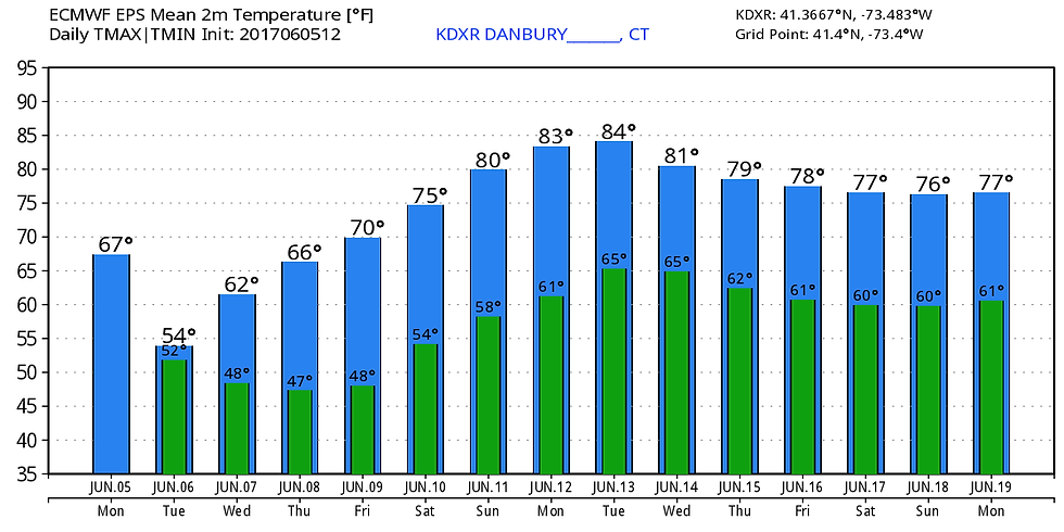
In case you were wondering, a heat wave is when there are at least three consecutive 90 degree plus days. We may in fact have a 4-day-long heat wave from Sunday, June 11 through Wednesday, June 14. Now we are still about a week away from this potential event, so the chance for a heat wave may either increase or decrease. As of now, we have a descent shot at achieving a heat wave. The temperature forecast below is from the European model. The temperatures that are in this graphic originate from the mean of all the 51 ensemble members of the European. I tend to find these numbers conservative, especially when you're talking about a week in advance. Therefore, that would bring the temperatures during the start of next week near 90 degrees.
The American (GFS) model is very bullish on the heat, but there is definitely the possibility for temperatures to get into the mid 90's, which is what the GFS model is predicting. Below is the temperature forecast by the American model for Monday. Keep in mind this forecast also looks very similar as Tuesday and Wednesday's, so a heat wave will happen based on this forecast.

Heat wave or not, a warm up is finally on the way, starting the end of this week and through the start of next week. It should remain mild into all of next week and hopefully that warm and dry trend continues for much of June because this year's spring has been super ugly!

As of now, the Climate Prediction Center is forecasting above average temperatures for the Northeast for the next two weeks. Once the heat arrives, I hope you will enjoy it as much as I know I will!


Comments