
JACKSON'S WEATHER
LOCAL WEATHER FOR SOUTHWESTERN CONNECTICUT
THE DAYS AHEAD
JULY 27, 2018
Average High: 83°
Average Low: 67°
Overall, a very nice Friday is ahead to finish the week and my tenure of Jackson’s Weather. Expect sunny to partly cloudy skies most of the day paired with a dew point at around 70 degrees, which is indicative of a sticky air mass. That added humidity will make the actual forecast high temperature in the mid 80s feel even warmer. A breeze will be present at times, at least. Now in the afternoon, a stray pop-up shower will be possible ahead of a strong to severe line of thunderstorms, which will move in during the evening hours after 8pm. Gusty winds, frequent lightning, and locally heavy rain will be the main risks posed by these storms.
Now on Saturday, the cold front will take its time to move through the area. Instead of coming in from behind Friday evening’s storms, it will wait until Saturday evening. With moisture still flowing in from the south ahead of the front, that may allow for a brief shower or storm to develop overhead during the mid- to late- afternoon. Otherwise, the day as a whole will be beautiful, featuring a blend of sun and clouds and a maximum temperature into the low 80s, which is about average for this time of the year. Again, the high humidity will make it feel a few degrees warmer than the actual temperature.
Sunday will be the nicer day out of the weekend thanks to the passage of the cold front. Sure, Saturday will be a great weather day, but Sunday will be even better because the chance for rain will be zero as high pressure briefly builds in overhead. That high pressure will allow for mostly sunny skies, a light wind, and significantly lower humidity. That dry air will make it feel very pleasant out there, especially given the comfortable high temperature of about 80 degrees.
We’ll begin the start of the new week with a continuation of the dry weather on Monday. Humidity and winds will remain on the lower end of the spectrum. That will be accompanied by sunny to partly cloudy skies and a peak temperature of about 80 degrees.
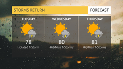
Now as we get into the midweek time period, a similar, stormy setup will likely return with a trough of low pressure over the interior East and a large, subtropical high pressure off the East Coast. These two features will work in conjunction to steer large amounts of moisture from the Caribbean Sea up through the northeastern US, thus allowing for days of stormy weather. On Tuesday, expect the day to be dry for the most part besides a possible afternoon thunderstorm. The big difference on Tuesday will be the return of the moderate to high humidity, which will really make the forecast high of 78 degrees feel warmer.
Wednesday and Thursday look to be the stormiest of days next week. On Wednesday, expect hit or miss showers and thunderstorms at any time of the day with breaks of sunshine in between. Expect any of this rain to produce heavy downpours, which may lead to localized flash flooding given the extremely moist atmosphere. Precipitable water values may exceed 2 inches, which often signifies the high likelihood for heavy rain. It will also be very humid and quite breezy out there on Wednesday,
On Thursday, it will be a rather similar day as Wednesday with numerous rounds of showers and storms. Because this is far out in time, it’s hard to tell how numerous this precipitation will be but the chance for rain will definitely present. What I am confident in is that is will remain sticky and breezy outside with a high temperature near 80 degrees.
It has been an honor to produce these forecasts daily for over the past three years. Jackson’s Weather wouldn’t have been existent if wasn’t for you. I am feeling bittersweet as I write this final forecast, and I will miss this opportunity immensely but am excited for the times ahead. Hopefully in a few years from now, I will be able to follow my dream by giving the weather forecast forecast on a different platform - TV. For a final time for Jackson’s Weather, have a great day!


TODAY'S EXCLUSIVE RATING
July 27, 2018
OTHER FORECAST GRAPHICS
 Hourly Forecast |  Weekend Outlook |  Beach Forecast |
|---|---|---|
 Storms Return |  Seasonable Stretch |
CLOTHINGCAST
SUNGLASSES
UMBRELLA AT HAND
T-SHIRT
MORE WEATHER
